
If you were like me, the first time that you saw a land description like this one: NW¼ , NW ¼, S11, T2N R2W, Tallahassee M., you shook your head and murmured to yourself “I thought that I was through with algebra 40 years ago.” But to effectively use the land records of the public-land states, you must learn to read land descriptions based on the rectangular survey system and learn how to locate the described land on a map. Besides, it is a lot easier than it looks, and it is much closer to geometry than to algebra.
The rectangular survey system is also known as the Cadastral system, or the Public Domain Survey system. It has been used to plot public domain since 1786, when lands in
While not intuitive, it is a surprisingly simple system. When the government wanted to sell publicly owned land, they would establish an arbitrary starting point through which a meridian passed – meridians are those imaginary north/south lines that divide up the earth on your globe. An arbitrary east/west Base Line, perpendicular to the selected Meridian and crossing that meridian, was then established.
An imaginary grid of squares known as Congressional Townships, commonly just called townships, was then placed on the land, using the intersection of the selected
Those townships located north of the base line are referred to as North or "N". Those south of the base line are referred to as South or "S". Ranges to the right, or east, of the Principal Meridian are considered as East or "E", while those located to the left, or the west of the Principal Meridian are labeled as West or "W".
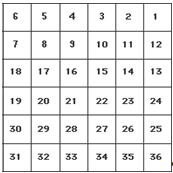 Each Township contained six square miles of land, divided into thirty six numbered sections containing 1square mile of land. The numbering system is not intuitive. It starts at "1" in the uppermost NE section and proceeds west to section 6, then south one section, which is section 7, then east again to section 12, south one section to section 13, then west again to section 18, and so on.
A township might, for example, be identified as Township 2, North, Range 2, West, which would mean that it was located in the 2nd tier of townships north of a baseline and in the 2nd range or column of townships west of the selected meridian
This next figure provides a visual example of how this works. In this example, the 40 acre piece of land in the extreme upper left of section 11 would be legally described as the NW ¼, NW ¼, S 11, T2N, R2W, Tallahassee. In English, this becomes the Northwest 1/4 of the Northwest 1/4 of Towhship 2 North, Range 2 West, using the Tallahassee Meridian.

Maps – Placing Your Ancestors on the Land Where They Lived
The Township, Range, and Section numbers have not changed since the original surveys. As a result, superimposing the rectangular survey grid over a map of the county where your ancestors owned land allows you to very quickly and easily locate the land on the map. This is true even though the property may have started in one county and ended up in another county.
Plat Maps – These maps show the area divided by township, range, and section. Check your State Archives – they often have original plat maps for each county by Township and Range. The map below is the plat of Jackson County, Florida Township 3 N, Range 10 West. The map was created from an 1826 survey, but the marked off sections on the maps are the plots of land that were sold up through the 1850s.

The numbers written in the sections are patent certificate numbers. They can be used on the BLM-GLO web site to identify the owners.
Plat maps get really interesting when they are more modern maps showing roads, towns, churches, and cemeteries. Using the map and the information that you have gained, you can locate the towns, churches, cemeteries, and schools closest to the land. These are the facilities and institutions most likely used by your ancestors. If you choose, you may be able to visit and actually walk on the land owned by your ancestor, or find the old house your ancestors lived in.
You can get some of these modern plat maps free from your State of interest’s Department of Transportation. Also, many county property tax departments have Township and Range maps that are available for a small fee. In addition, Arphax (www.arphax.com), a map publishing company, is in the process of publishing, state by state and county by county, township maps that plat all original patentees. This is Department of Transportation map:

Great post - really helpful and thanks for sharing.
ReplyDeleteVery Helpful. Thanks!
ReplyDeleteThat has helped me more than any text book I have read!
ReplyDeleteThank you!!!